The Kahramanmaraş Supersite is strongly supported by the Space Agencies participating to the CEOS Working Group on Disasters:
https://ceos.org/news/kahramanmaras-event-supersite/
The following EO data are available for scientific use.
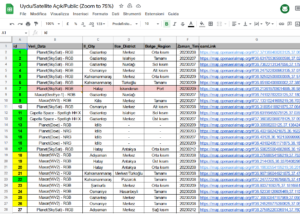
COSMO-SkyMed stripmap images
ASI post-seismic interferometric acquisition plan for COSMO-SkyMed satellites (repeat pass:16 or 24 days):
The CSK-CSG data are distributed through the Geohazard Exploitation Platform- GEP, under the folder Turkey EQ 2023
You can freely browse through the archive, but to be able to download the data, you have to follow the procedure described here
Note that before the event there were only a limited number of frames acquired over the area.
SAOCOM stripmap images
ASI interferometric acquisition plan for SAOCOM:

The SAOCOM data are distributed through the ASI SAOCOM data hub., but can be browsed also from the CONAE catalog.
To be allowed to browse and download the data from the ASI SAOCOM data hub, you need to register your membership (join the license to use the data). To do this you should go to https://www.asi.it/en/earth-science/saocom/ and follow the procedure explained in the Membership guide.
If you find the guide too dispersive, read below for a quick way to register (please have patience and read to the end...):
Pléiades Very High Resolution optical images
CNES will provide access to a quota of 5000 sq/km of new Pléiades VHR acquisitions.
Please contact the Supersite coordinators if you are interested in using these data for research.
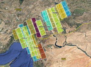
Initial areas selected for acquisition are:
Aerial photos
Aerial photos and orthophotos from the Turkish Ministry of National Defense, General Directorate of Mapping
Very High Resolution optical images from MAXAR

Open Geographical and EO data
A number of maps and EO data are available in the Geoportal of the HGM-General Directorate of Mapping.